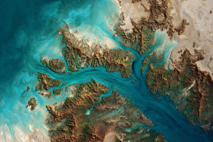
The synergy between space technology and Earth observation has significantly advanced with Landsat 9. Most importantly, when its Operational Land Imager 2 (OLI-2) captured the dramatic landscape of the Buccaneer Archipelago on June 11, 2025, it delivered fresh insights into the dynamic coastal ecosystems and tidal forces that shape one of Western Australia’s most intriguing natural wonders. Because this technology continues to evolve, the images offer both aesthetic appeal and vital scientific data that are essential for environmental research.[4]
Furthermore, the captured imagery represents an intersection of cutting-edge sensor technology and decades of remote sensing expertise. Therefore, Landsat 9 not only enhances our understanding of natural processes but also sets the stage for more refined studies into coastal dynamics in other parts of the globe.
The Buccaneer Archipelago: A Place of Tides and Beauty
Located where King Sound meets the vastness of the Indian Ocean, the Buccaneer Archipelago spans hundreds of islands, rocky reefs, and meandering channels. Because the region is sculpted by some of the world’s strongest tidal currents, enormous sediment flows create a palette of shifting turquoise hues that are nothing short of mesmerizing. This dynamic interplay underlines the powerful natural forces resulting in constantly evolving coastal forms.[4]
Moreover, this intricate mosaic of water and landforms is of great interest to geologists and oceanographers. Most importantly, studies here contribute vital information on sediment transport and coastal erosion—a critical need in the face of climate change. Besides that, the area’s hazardous waters, notably around pinch points like Hell’s Gate, further emphasize the importance of accurate satellite observation. Learn more details from the comprehensive overview provided by NASA here.
Landsat 9: Pushing the Frontier of Earth Observation
Launched in September 2021, Landsat 9 continues the legacy of sustained Earth imaging by offering heightened imaging capacity and state-of-the-art sensors. Because its OLI-2 sensor captures images in visible, near-infrared, and shortwave infrared bands, scientists now have more precise and richer data than ever before. In addition, its partner instrument, the Thermal Infrared Sensor-2 (TIRS-2), supports comprehensive environmental studies by mapping heat emissions dedicated to understanding urban heat islands and natural temperature variations.[1][3]
Moreover, Landsat 9’s refined orbital dynamics—flying in tandem with its predecessor, Landsat 8—ensure that nearly every location on Earth is revisited regularly. Most importantly, the complementary operation of these satellites, with angular revisit cycles every eight days, paves the way for high-frequency monitoring of rapid environmental changes. As noted by NASA’s Earthdata resources, this consistency is critical for setting long-term climate baselines.[1][3][5]
Why Landsat 9’s Latest Image Matters
The striking image of the Buccaneer Archipelago is not only visually stunning but also a technical milestone and scientific beacon. Because the area’s extreme tidal forces stir up suspended sediments, the resulting imagery offers researchers a reliable dataset for examining coastal erosion, water quality, and broader ecosystem health. Therefore, these observations are invaluable in modeling sediment transport and predicting future changes in shoreline configurations.[4][2]
In addition, high-frequency imaging empowers local authorities and conservationists to better manage marine habitats and respond in real-time to environmental hazards. Most importantly, data continuity from the seamless integration between Landsat 8 and Landsat 9 means that long-term environmental trends are observed without interruption, strengthening climate resilience strategies. For further insights into how Landsat 9 advances coastal studies, please visit the detailed article on NASA’s Landsat 9 Overview.
A New Era for Coastal Monitoring
The Buccaneer Archipelago serves as a premier example of next-generation satellite imaging. Because repeated observations allow scientists to differentiate between abrupt environmental events and gradual natural transitions, the data from Landsat 9 provides an essential foundation for predictive modeling and environmental management. Besides that, the survey of these turbulent coastal waters delivers insights that extend well beyond the archipelago’s boundaries.[5]
Furthermore, this technological breakthrough is paving the way for new approaches in coastal monitoring. Because decision-makers now have access to real-time, high-resolution imagery, public policy and conservation efforts stand to benefit drastically from this impartial, science-based data. Most importantly, this technological progress contributes significantly to the global response to issues like sea-level rise and biodiversity loss.
Technological Precision in Action
Landsat 9’s rapid revisit cycle, along with its moderate-to-high spatial and radiometric resolution, ensures that environmental monitoring is both precise and timely. Because the OLI-2 and TIRS-2 sensors detect not just visible light but also subtle variations in heat and vegetation stress, researchers can pinpoint early signs of environmental change. This is crucial for areas vulnerable to urban development and industrial impacts.[1][3]
Moreover, the integration of advanced sensor technologies with an open data policy forms a robust platform for global environmental monitoring. Most importantly, this synergy enables the scientific community and public stakeholders to collaborate and innovate solutions for managing natural resources. For an in-depth look at Landsat 9’s capabilities, browse the mission details provided by eoPortal here.
References
[1] eoPortal: Landsat-9 Mission Overview
[2] Space Launch Schedule: Landsat 9 Sees Buccaneer Archipelago (view article)
[3] NASA Landsat Missions: Landsat 9 Overview (learn more)
[4] NASA Image Feature: Landsat 9 Sees Buccaneer Archipelago (read the feature)
[5] NASA Earthdata: Landsat 9 and the Continuous Global Earth Imagery Record (explore more)


